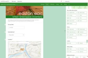
Screenshot from Survey 1-2-3 data collection tool, developed by the City of Easton EAC
Geographic Information Systems, or GIS, is a powerful tool for organizing, tracking, analyzing, and visualizing data so that it can be used effectively to support environmental resource management and protection. The possible applications are vast, from analyzing land cover and change, to managing invasive species; from mapping riparian buffers, floodplains, recharge areas and other water-related resources, to inventorying municipal open space areas to improve management. However, for those without a background in GIS, the prospect of using this tool for your EAC project can be daunting.
Through this technical assistance program, WeConservePA GIS Analyst, Irina Beal, will work with EACs to set project parameters and list desired deliverables; determine feasibility based on current available data; identify appropriate tools; and provide guidance and documentation throughout the process.
Types of Assistance Provided:
- Tutorials/manuals on most common and most practical tools
- Acquisition of data
- Guidance on data collection strategies and methodology for new data
- Data processing and visualization
- Delivery of static or dynamic maps, statistics, reasonable reports and/or summary of findings
Application and Review Process
If your EAC would benefit from GIS technical assistance for an upcoming project, email ibeal@weconservepa.org.
Please include the following details:
- EAC Name
- Representative name and contact information.
- A short description of the project scope of work, including:
- Area of interest, i.e. municipal boundary, watershed boundary, or the boundary of your study area
- Resources of interest, i.e. topography, soils, tree cover, etc.
- Desired deliverables, i.e. map for print or website, report to aid in future decision-making processes, summary of natural resource inventory
Technical assistance requests will be considered on a first-come-first-serve basis, and in order of complexity. If your project is accepted, Irina will contact the project representative to schedule an initial meeting. Subsequent steps will vary depending on the scope and needs of individual projects.
Learn More
Interested in learning more? Download and view the recording from our April 16 presentation, GIS Options for Environmental Advisory Councils. GIS Analyst Irina Beal provides an overview of available tools and datasets, and how WeConservePA can assist EACs, while Ian Kindle of the City of Easton EAC delves into how the EAC is undertaking a comprehensive survey of public and private greenspaces within the city to prioritize environmental benefits, including beautification and sustainable maintenance.