Supported by the Chester County Water Resources Authority and the University of Delaware Water Resources Center, the flood study will identify opportunities for future flood mitigation measures to better protect residents living along the Brandywine Creek in Pennsylvania and Delaware.
In response to more frequent and extreme flooding events impacting communities along the Brandywine Creek in both Pennsylvania and Delaware, the Brandywine Conservancy announced the launch of the Brandywine Flood Study—nearly two years after Hurricane Ida produced historic flooding that devastated the region. Conducted in partnership with the Chester County Water Resources Authority (CCWRA) and the University of Delaware Water Resources Center (UDWRC), the flood study is a coordinated effort to better understand where and why flooding occurs and identify the best approaches to protect our communities from future severe flooding events.
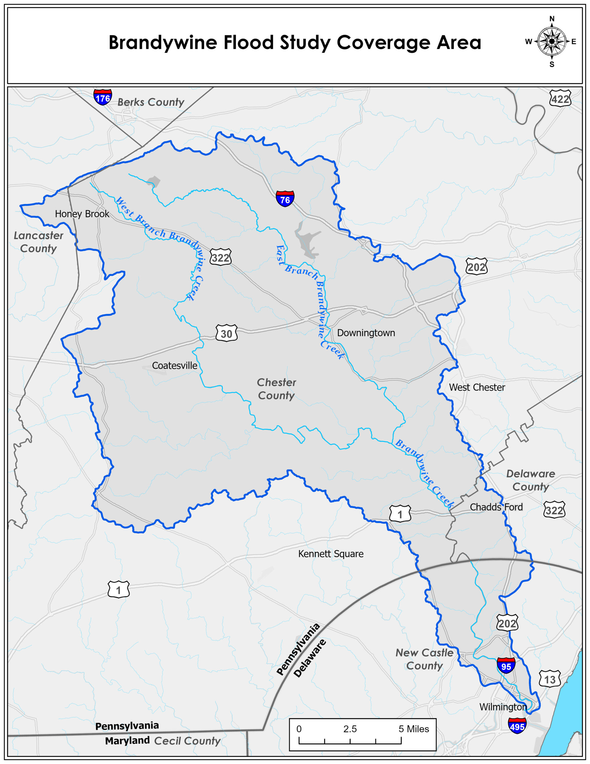 Encompassing the mainstem of the Brandywine Creek and key tributaries in Chester and Delaware Counties in Pennsylvania and traveling downstream to impacted areas over the Delaware state line, the flood study aims to identify options for reducing flood impacts to improve public safety and lessen property damage. The study will be funded, in part, through grants from Chester County Government and Delaware County Council.
“As we approach the two-year anniversary of Hurricane Ida, which caused significant threats to public safety and emergency services, along with over $100 million in flood damages to public infrastructure in our region—including more than $10 million in damages to the Brandywine Conservancy & Museum of Art’s 15-acre campus in Chadds Ford—there is an urgent need for this flood study,” said Grant DeCosta, Director of Community Services for the Brandywine Conservancy. “In order to identify the best strategies for mitigating the impact of future flooding events, we need to better understand all of the factors that contribute to flood levels along the Brandywine Creek and its tributaries. Given the increasing likelihood of future severe weather events, the Brandywine Flood Study is key to our community’s health and safety.”
Led by the Brandywine Conservancy, CCWRA and UDWRC, the study will evaluate the Brandywine Creek’s flow regimes during intense storm events, along with the scale and potential impact of subsequent flooding. The study will also include Stroud Water Research Center, West Chester University and other technical experts as key partners.
“On behalf of Chester County, the Water Resources Authority is proud to be a partner in this watershed-based approach to identify a range of solutions that address flood impacts in our communities,” said Seung Ah Byun, Executive Director of the Chester County Water Resources Authority. “We also view this as a way to build resiliency and mitigate the potential effects from future storm events that may be larger and more intense due to our changing climate. Approaching this from a more regional scale is important, because what our upstream communities do affects our neighbors downstream.”
One of the first tasks of the flood study will involve refining the study area to determine all the streams and tributaries with flow regimes that contribute to major flood events. The study partners will then evaluate the designated area’s storm event and climate data, population, land use, water quality, natural areas and cultural resources. Historical and present flooding data will also be evaluated, and then the partners will develop hydrologic and hydraulic models of the Brandywine Creek using the U.S. Army Corps of Engineers’ Hydrologic Engineer Center’s River Analysis System (HEC-RAS). Using these models, the partners will identify problems associated with the geography and hydrology of the flood study area. This process will also include public workshops and field reconnaissance of the defined study area.
“In 2021, Hurricane Ida sideswiped our area and caused the biggest flood in 200 years along the historic Brandywine Creek. At the University of Delaware Water Resources Center, we look forward to working with our upstream partners in this bistate and intergovernmental Brandywine Flood Study to identify the root causes of the flooding, as well as recommend and hopefully implement real flood solutions for the people who live and work in the watershed in Delaware and Pennsylvania,” said Gerald Kauffman Jr., Director of the University of Delaware Water Resources Center.
Following the data gathering and field study phase, the partners will begin site assessment for improvements to the flood study area to mitigate future flooding. The recommended solutions will be evaluated for various factors, including impact and cost, in order to facilitate strategic implementation throughout the study area.
Chester County Commissioners Marian Moskowitz, Josh Maxwell and Michelle Kichline said, “Chester County has more than 100 years of continuous stream flow records for the Brandywine Creek at Chadds Ford, and during Hurricane Ida, the creek crested at over 21 feet—nearly four feet higher than the previous highest recording. Chester County has a rich legacy of sound planning and environmental stewardship, and we know that it is important to continue to plan and prepare for future conditions that involve extreme weather patterns. This flood study is a key step in the preparation.”
“We are thrilled to support the Brandywine Flood Study, led by the Brandywine Conservancy in partnership with the Chester County Water Resources Authority and the University of Delaware Water Resources Center,” said Delaware County Council Chair, Dr. Monica Taylor. “This coordinated effort will be key to helping us better protect our communities from future severe floods and will help us more fully understand and respond to all of the contributing factors that lead to extreme flooding along the Brandywine Creek in Pennsylvania and Delaware.”
The study is expected to be completed by June 2024. A series of public workshops will be held during key stages of the flood study process to engage with impacted communities and gather feedback. The partners also plan to form a flood advisory committee made up of key stakeholders along the watershed. The public can stay informed on the flood study progress, along with upcoming public meeting dates and locations, at brandywine.org/flood-study.
Once the flood study is completed, the partners are committed to working with impacted communities, elected officials, key funders and government agencies to implement the study’s recommendations so that the watershed and its residents in both states are better prepared, protected and equipped to rebound from future severe flooding events.
About the Brandywine Conservancy:
The Brandywine Conservancy protects water, conserves land, and engages communities. The Conservancy uses a multi-faceted approach to conservation. Staff work with private landowners who wish to see their lands protected forever and provide innovative community planning services to municipalities and other governmental agencies. The Conservancy currently holds more than 510 conservation and agricultural easements and has facilitated the permanent preservation of over 70,200 acres of land. The Conservancy is a program of the Brandywine Conservancy & Museum of Art, which preserves and promotes the natural and cultural connections between the area’s beautiful landscape, historic sites, and important artists.
About the Chester County Water Resources Authority:
The Chester County Water Resources Authority (CCWRA) provides water resource management, science, and planning services to support thriving communities and healthy watersheds in Chester County. CCWRA was established in 1961 by the Chester County Board of Commissioners, under the PA Municipality Authorities Act, to implement the Brandywine Creek Watershed Workplan. From 1961 through 1994, in partnership with the U.S. Department of Agriculture, CCWRA led the local efforts to implement the plan through the planning and construction of five regional flood control facilities and two regional water supply reservoirs. CCWRA is also leading the development of Chester County’s integrated water resources plan, Watersheds 2045, which is expected to be released completed by December 2023. Watersheds 2045 provides a planning framework to empower communities and stakeholders across Chester County to protect, sustain, enhance, and enjoy our shared water resources, both today and in the future.
About the University of Delaware Water Resources Center:
Established in 1965 as one of the 54 National Institutes for Water Resources (NIWR) at land grant universities in the 50 states, District of Columbia, and three island territories of Guam, Puerto Rico, and U.S. Virgin Islands, the University of Delaware Water Resources Center (UDWRC) is Congressionally chartered by Section 104 of the Water Resources Research Act of 1984 and 1964 administered by the U.S. Department of the Interior and U.S. Geological Survey. As part of the NIWR network, the mission of the UDWRC is to: (1) support research, education, and public outreach programs that focus on water supply, water management, and water quality – issues important to Delaware citizens and (2) foster/support training and education programs for future water scientists, engineers, managers, and policy-makers who will lead the water resources research, planning, and management efforts in our state and region. Since 1977, UDWRC has provided water assistance to governments in Delaware through the land-grant public engagement (service), learning (education), and scholarship (research) role of the University of Delaware as sponsored by a board of the State of Delaware, New Castle County, and Newark and Wilmington.