The Chester County Planning Commission recently wrapped up an 18-month study to determine the feasibility of developing a multi-use trail connecting Chester County’s southern communities to the Circuit – Greater Philadelphia’s existing multi-use trail network.
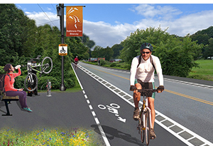
Major project recommendations included 20 miles of bicycle and pedestrian improvements along Baltimore Pike to create a unified “Baltimore Pike Bikeway,” and two multi-use trails along the US 1 Expressway: one in the in Kennett area, and one in the Oxford area.
Commenting on the trail study, Chester County Commissioners Marian Moskowitz, Josh Maxwell and Michelle Kichline said, “In the 18 months since this study began, we have all come to appreciate, even more, the value of trails, not just for walking, biking and de-stressing, but for alternative methods of transportation.”
The two recommended multi-use trails would be coordinated with PennDOT’s current project to reconstruct the US 1 Expressway. These two proposed trails – one 3.5 miles long and the other five miles long – would serve as stand-alone amenities addressing the region’s strong interest in recreational trails.
Additionally, further study to determine the optimal trail alignment between Schoolhouse Road in East Marlborough Township and the Brandywine Creek was recommended, as well as a loop trail in Jennersville, and a connection from Nottingham Village to Nottingham County Park.
Because of early public interest in developing a trail along the US 1 Expressway, the Planning Commission has already begun working with PennDOT and other key partners to implement the recommendations and next steps from this study.
The Southern Chester County Circuit Trail Feasibility Study was first identified in Chester County’s Comprehensive Plan, Landscapes3, as a way to provide the communities in the county’s southern region with high-quality recreational amenities and a safe multi-modal transportation corridor like the Chester Valley Trail in the central part of the county and the Schuylkill River Trail in the north. Optimally this trail would span 20+ miles from Oxford Borough (in the west), to Chadds Ford (in the east), where it would connect to the Circuit.
The project placed significant emphasis on collecting public input and featured numerous opportunities including two online public meetings, interviews with community leaders, focus groups, presentations at local schools, discussions with municipal planning organizations, and a public survey in English and Spanish.
“We thank everyone in the region who took part in this feasibility study, to ensure future trails in Southern Chester County connect communities, as well as join the Circuit,” added the Commissioners.
While the study ultimately determined that it is not feasible to develop a continuous multi-use trail along this corridor, it did, however, recommend several major projects as well as a number of targeted local projects.
The Southern Chester County Circuit Trail Feasibility Study was funded in part by a grant from the Regional Trails Program, administered by DVRPC with funding from the William Penn Foundation. The scope of the work spanned from January 2020 to June 2021.
To learn more about this project – including the final plan– please visit https://www.chescoplanning.org/transportation/SouthernChesco.cfm.